


Surveying has been around almost as long as the human race. The Romans used it to divide land, the Egyptians used it for the pyramids, whilst prehistoric man employed survey techniques to build Stonehenge.
But, despite it being a part of our construction process for such a long time, there’s still many of us who are left baffled by the different types of survey available. Is it a topographical survey you need or maybe a measured building? A full utility survey or will just recording the manholes be enough?
Here we try to explain the differences between each survey, and why they are important for your project:
 Put simply, a measured building survey produces exact drawings of your building project. These drawings are accurate representations of your building and can be as detailed or as simple as you need. Measured building surveys can include floor plans, elevations and cross sections of both internal and external structures. A good surveyor will work to record the level of detail you require, and create accurate drawings to match your specifications.
Measured building surveys are generally used for building redevelopment projects, and play an important part in the renovation process. Architects and building planners will need to know exactly what they’re starting with, and the drawings created from a building survey will form the base of their plans and designs.
Following the development of laser scanners as a survey tool, measured building surveys can now be conducted to increasingly high levels of accuracy. Very detailed structures can also now be scanned, preserving architectural features, identifying areas in need of renovation or creating 3D fly-through models.
 Topography means ‘description of place’, and in basic terms, this is exactly what a topographic survey does. It measures points of elevations across the ground, and gives exact figures as to their height, size and position. A topographic survey will identify existing features, whether these are natural or man-made, such as trees, buildings, streets and walkways. It also shows the contours of elevations and distributions in the land surface. A topographic survey is usually conducted using a total station, with the results converted into 2D or 3D drawings for the client to work from.
Why is it important? A topographic survey is vital for most building projects, as it gives developers the necessary knowledge of the land they will be working on. Topographical surveys are usually conducted at the very beginning of a project, with designs and future plans drawn up using the survey data.
As the name suggests, this survey is designed to identify boundary lines on land. A boundary survey will usually start in the office, with desktop research into property deeds, archived OS maps and other historic legal documents. It’s important to know exactly where your property boundaries lie, so that construction doesn’t cross over onto somebody else’s land.
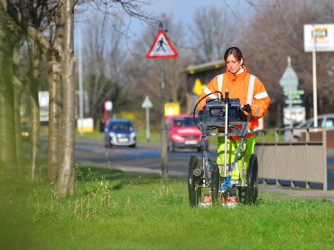 Commonly known as utility mapping – a utility survey is designed to identify utility cables or pipes located underground on your site (such as gas, electric cables, drinking water etc.). Where possible, the survey will establish the depth of the utility and can give an indication of the dimensions of the pipe. Utility surveys can be conducted non-intrusively, usually by GPR or electromagnetic techniques. The results of the survey can be provided in a drawing, which allows you to plan your site development with improved time efficiency and the necessary knowledge with regard to utilities on site.
Especially important for health & safety, a utility survey is usually a legal requirement for any building project where ground penetration is required. Knowing the location of potential hazards also helps avoid any unnecessary excavations on site and identifies safe locations for things such as boreholes, soil sample digs and trial pits.
A drainage survey can be undertaken at a number of different levels.
 At the most basic level, a manhole survey will identify and lift manhole covers, and record their size and what’s inside. If you already have knowledge or records of the utilities through your site, this survey may be all that you need to confirm your information is correct and up to date.
However, records of the drainage system can often be non-existent or poor quality, especially if they are old or if the site has had numerous uses over the years. If this is the case, you may need a more comprehensive drainage survey. This survey is designed to check the drainage networks throughout the site. Surveyors will check the routes of drainage and levels to see if the network is still capable of draining properly.
 If you need to know the condition of drainage networks, the only sure fire way of recording this is to conduct a CCTV survey (or a walk-through inspection for larger sewers or culverts). This allows the surveyors to see what condition the system is in, and establish if there are any obstructions such as tree roots or heavy silt blocking the system. A full CCTV survey is the only way to confirm the drainage routes are in working condition, prior to putting them to the test once the project is complete.
An existing drainage survey will form part of a full flood risk assessment. However, even if this isn’t a requirement of your site, it’s of great importance to check prior to any building work or new developments that suitable drainage is in place. Not doing so could cause big problems later on in the construction process!
 Other types of Geophysical Survey
When it comes to determining exactly what lies beneath our feet, our geophysics team are regularly called in to help with a range of investigations. We use a combination of techniques to help clients better understand their site, including archaeological surveys, landfill and ground contamination, underground hazards, void location and even mapping badger setts!
Hopefully, this has made it a little easier to understand and decide which types of survey are right for your project – even if you aren’t building the pyramids or Stonehenge! Often surveying is the initial step in any building project – so if you need assistance, or have questions on which surveys may be required for your project, our team of expert surveyors, geophysicists and engineers can help.

Contact us for an informal chat to discuss your requirements, by phone: 0113 200 8900, email: admin@metconsultancygroup.com or complete our contact form.
Comments Off on From topo to utility – an introduction to the different types of survey